2024 Study Architecture Student Showcase - Part XVI
Welcome to the final installment of the 2024 Study Architecture Student Showcase! It’s been a pleasure to celebrate these inspiring student projects.
Part XVI features student work that reimagines various housing typologies. From high-rise developments and mixed-use buildings to affordable single-family units, each project thoughtfully addresses critical housing issues. The presented design solutions involve incorporating machine learning into the design process, integrating various housing types, and much more. Scroll down for a closer look!
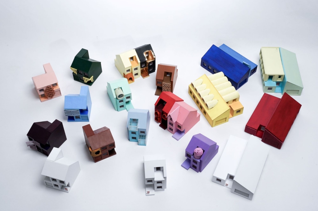
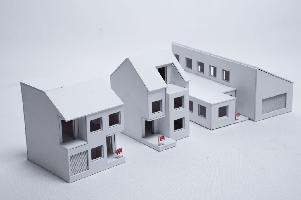
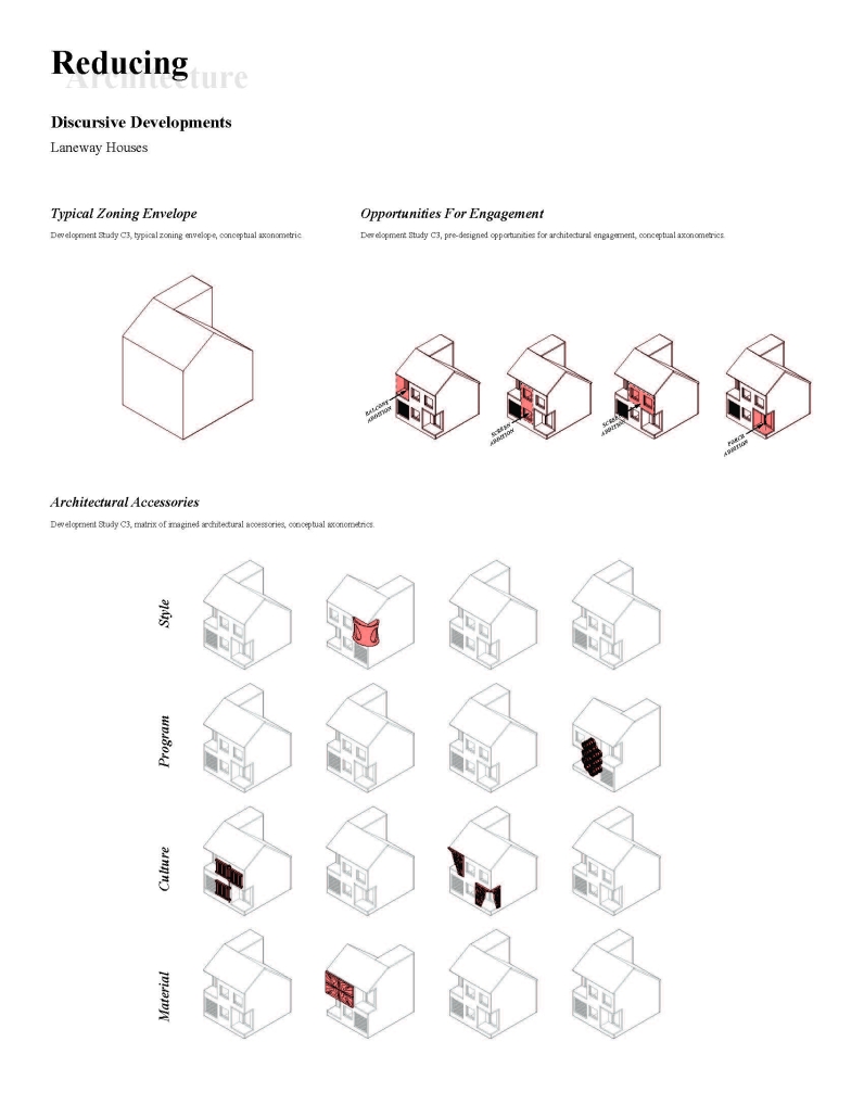
Reducing Architecture by Thomas Steven Tencer, M. Arch ‘24
University of Toronto | Advisor: Carol Moukheiber
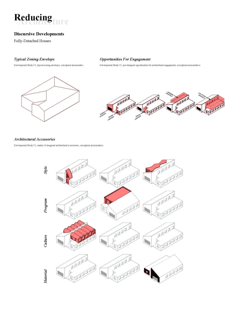
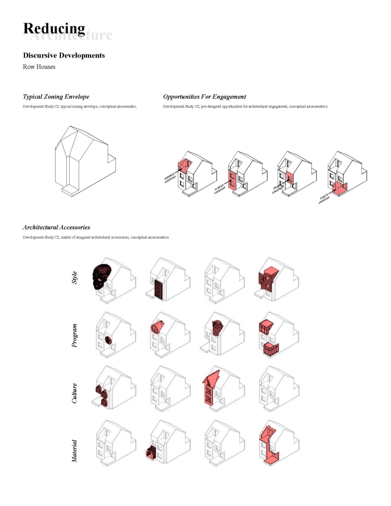
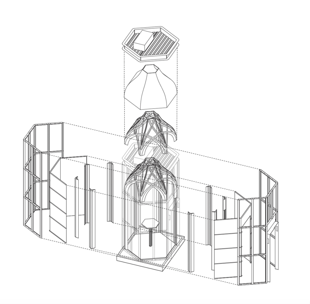
Reducing Architecture is a system-based design approach that strives to make the expression of architectural identity more accessible. Architectural discourse often critiques suburban sprawl and the suburban aesthetic (it is unaffordable in an urban context, lacks density, projects outdated images of domesticity, and promotes land ownership which some consider criminal). However, since architecture is so disconnected from the development and design of single-family homes (influencing the design of less than ten percent of this housing type), 1) the practice is incapable of engaging with, disrupting, or affecting the future of the single-family medium.
Reducing Architecture proposes that architecture re-engage single-family housing, which remains Canada’s predominant housing type. 2) By disconnecting architectural expression from longer-lasting building layers, the creation of longer-lasting, higher
performing, and less costly houses is enabled; “A Primed Canvas.” 3) Onto this “canvas” distilled and articulated architectural expressions can be applied, at smaller scales and lower costs, so as not to disrupt the economies of scale achieved by mass-produced developer-built single-family housing. The result is a novel method for the expression of architectural identity, which is accessible, affordable, and efficient. Re-engaging single-family housing enables a discourse that may allow architecture to begin to influence the suburban aesthetic and morphology, rather than ignoring the medium in an act of architectural complacency.
Through Reducing Architecture, the single-family home could become more beautiful, more efficient, more culturally relevant, or more environmentally sensitive, so long as the architectural expressions that result from these objectives remain efficient, affordable, accessible, and desirable to consumers.
1. John Brown, “The Architect and the Single-family House,” Canadian Architect, September 30, 2002.
2. Government of Canada, “Type of Dwelling Reference Guide, Census of Population, 2021,” Statistics Canada, 2022.
3. Bernard Leupen, essay, in “Frame and Generic Space a Study into the Changeable Dwelling; Proceeding from the Permanent,” 010 Publishers, 2009, 33-34.
Instagram: @tommytencer
UrbanBots by Karan Patel, Mike Saad & Jacob Sam, M.SC in Architecture ‘24
New York Institute of Technology | Advisor: Sandra Manninger
Overview:
ARCH 702B is the second Advanced Architecture Design Studio in the Master of Science in Architecture, Digital Technologies program at the School of Architecture & Design at the New York Institute of Technology. The studio adopts an applied research approach, focusing on computational design through the development of digital experiments. Depending on the project, students engage with architectural challenges via expert and learning systems in individual, group, or class-wide projects. The studio critically examines the impact of technological advancements on design and fabrication patterns.
Project Focus:
This term, the studio’s focus is on mixed-use housing projects in Manhattan’s Garment District, inspired by the City of Yes initiative by the Department of City Planning. The initiative aims to update New York City’s zoning regulations to support small businesses and create affordable housing. One key strategy is converting underused office spaces and other non-residential areas into mixed-use housing, particularly targeting buildings constructed post-1961.
Motivation:
With hybrid work models becoming the norm, cities must adapt to address escalating housing shortages and rising rents. This transformation is crucial, especially given the national office vacancy rate of 18.6%, as reported by Cushman & Wakefield. The NYC Office Conversion Accelerator program has enrolled 46 buildings, with four already undergoing transformation to yield over 2,100 housing units.
Scope of the Project:
Location: Manhattan, New York
Boundaries: 23rd Street to 40th Street and 5th Avenue to 8th Avenue.
Methods of Assessment:
The assessment methods integrate machine learning (ML) techniques into the design protocol. The process involves three key stages:
Data Retrieval and Dataset Generation:
Collecting and organizing data relevant to the project
Creating comprehensive datasets to inform the design process.
Developing Protocols for 2D Information/Data:
Generating 2D representations and analysis from the datasets
Utilizing computational tools to explore design iterations and visualizations.
Developing Protocols for 2.5D Information/Data:
Extending 2D data into 2.5D models, adding depth and complexity to the visualizations
Applying ML techniques to refine and adapt these models to specific project requirements.
This structured approach ensures that students not only engage with advanced computational tools but also develop practical skills in generating and manipulating data for architectural design. Through this project, students gain valuable experience in leveraging generative AI and ML to address real-world urban challenges, positioning them at the forefront of technological innovation in architecture.
Instagram:@msact_nyit, @sandramanninger_studio
Ascending Worlds by Jose Power, M. Arch ’24
University of Toronto | Advisor: Jeannie Kim
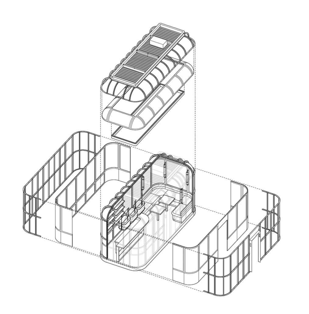
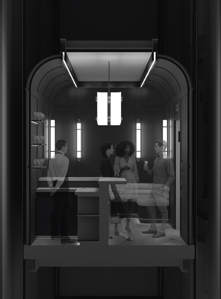
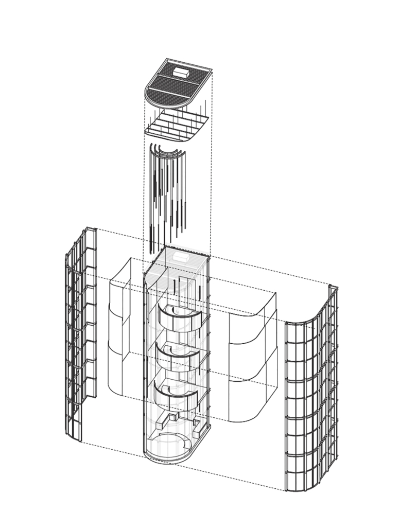
The social landscape of the residential high-rise has precipitated a disinterested and isolated vertical microcosm. The elevator, facilitator of this smooth vertical metropolitan condition, emerges as a pivotal yet neglected architectural space. Despite the expected brevity of our occupation of this instrument of density, the elevator also serves as a momentary junction where the anonymous lives of residents converge. This thesis delves into the elevator’s history and spatial conditions – including its velocity, scale, and temporality – to unveil a space rich in social potential. It aims to redefine the elevator as an instrument of architectural invention capable of reshaping the communal dynamics within residential high-rises.
Instagram: @jose_power21
Leveraging Density – A proposal for increased density permissions in exchange for affordable housing in Toronto’s Missing Middle by Joshua Giovinazzo, M. Arch ‘24
University of Toronto | Advisor: Carol Moukheiber
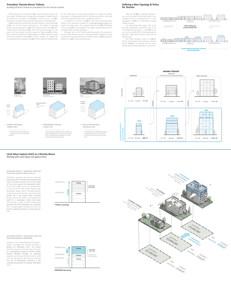
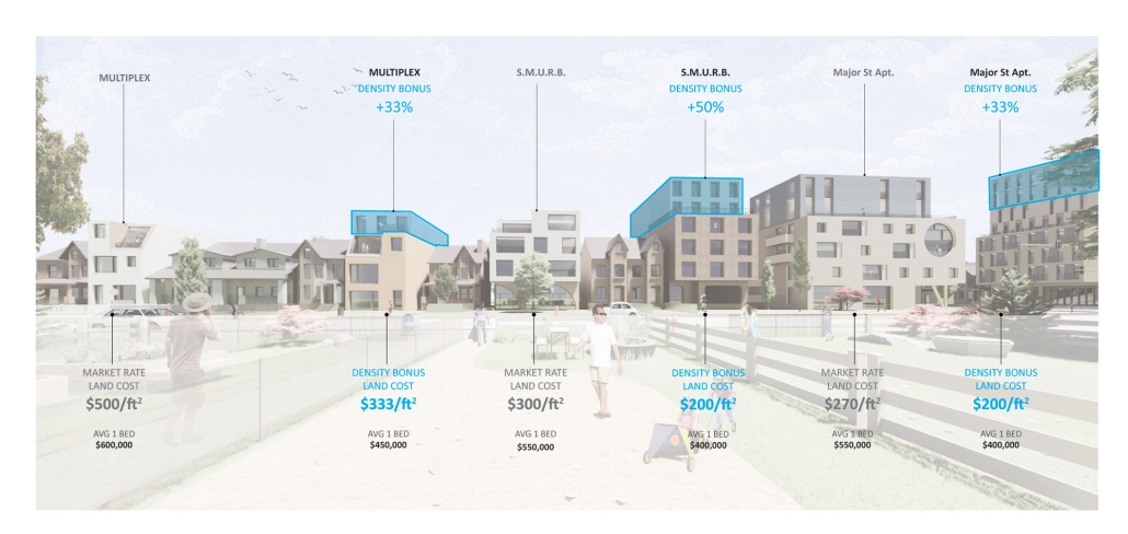
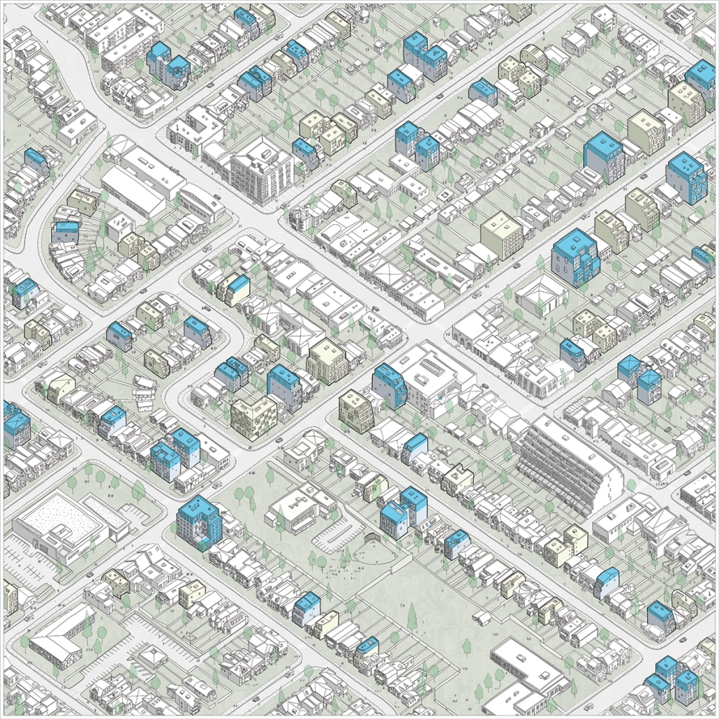
This thesis focuses on the intersection between the study of small-scale multi-unit housing typologies and a proposed new planning policy to directly create affordable housing in Toronto’s emerging missing middle.
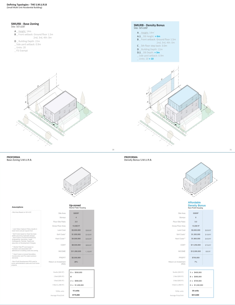
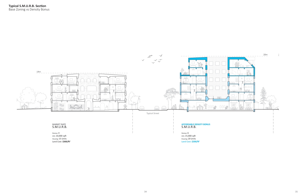
Working off existing conceptions of the transition zone, the S.M.U.R.B (Small Multi-Unit Residential Building) is proposed to help fill the density gradient between the existing multiplex and the upcoming Major Street Apartment. This formal solution is then complemented by the proposition of an as-of-right density bonus to systematically increase the supply of affordable units in our neighborhoods as they experience such a significant morphological change.
This policy-based solution is a response to Canada’s current myopic attempt to solve affordability through increased supply. Their approach, which embraces blanket upzoning – fails to define clear affordability targets, resulting in more of the same market-rate development. Learning from precedent policies in Seattle, Texas and Vancouver, the density bonus applied to small-scale housing looks to leverage these increases in density permissions by requiring a portion of the development as affordable housing.
‘Leveraging Density’ is rooted heavily in planning policy and construction finance, because housing is fundamentally the result of city planning and financial decision-making. This work does not focus strictly on an architectural resolution but rather looks to define a realistic framework for multi-unit housing affordability. This project is about the powerful systems that determine the built environment – defining what gets built and who benefits from it
This project won the Daniels Graduating Award.
Instagram: @joshua.giovinazzo.realtor, @UofTDaniels
The Half-House by Elodie Price, BS in Architecture ’24
University of Virginia | Advisor: Mona El Khafif
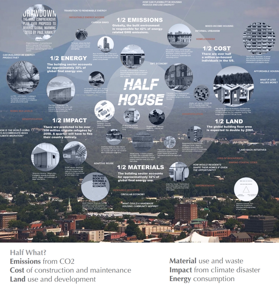
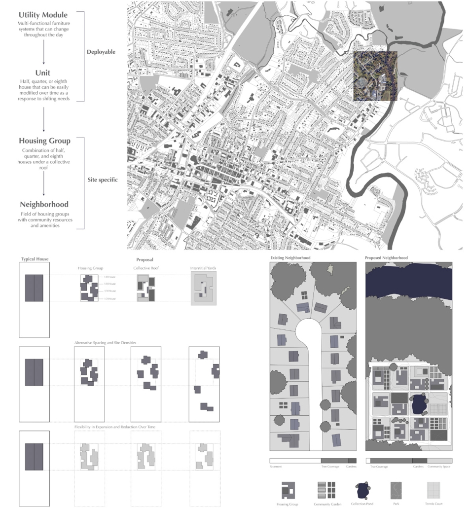
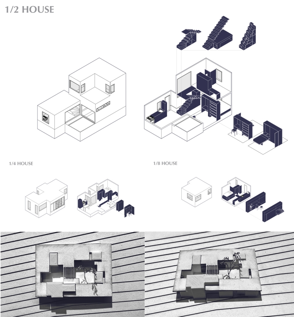
The Half House is a generative housing community that expands and contracts depending on changing needs and demographics within a community. The Half House intends to respond to the increasing socio-economic and environmental pressures the world is facing at a global and local scale while promoting the agency of the individual residents in conjunction with community enrichment. In contrast to the typical US house, the Half House minimizes itself in size, material usage, embodied energy, associated carbon emissions, and waste, while maintaining the same amenities and utilities as its counterpart.
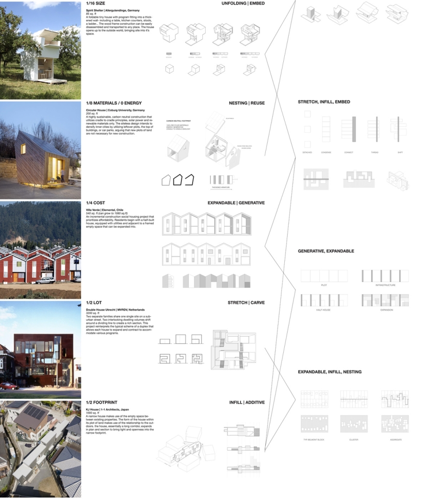
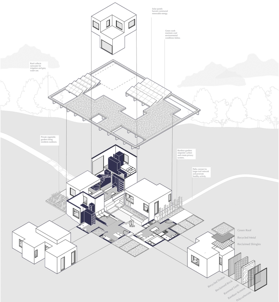
This project takes a stance on neighborhood planning, including shared spaces and the potential for growth and densification over time. Organized into housing groups, a combination of units co-exist below a collective roof, sharing exterior spaces, amenities and resources to contribute to a more environmentally and economically responsible lifestyle. In each housing group, there are solar panels collecting renewable energy, rainwater stored for gray water usage and irrigation, bamboo gardens that sequester carbon and naturally create privacy screens, and vegetable gardens to feed the community and provide healthy outdoor activities. Each unit follows a standardized set of dimensions in such a way that necessary additions (and redactions) can be easily made. The design of the individual unit is firmly based on precedent research and an investigation of the spatial strategies employed throughout a vast array of projects, including nesting rooms within each other, carving into a thickened wall, and flexible furniture. This project negotiates at the scale of the furniture module up to neighborhood planning, and furthermore, as a siteless, deployable object utilized for emergency housing, urban infill sites, or even accessory dwelling units (ADU’s) to densify suburbia.
The Half House embodies the idea that there is value in less. In a spotlighted prototype of a housing group arrangement that is a focus of this project, fractional units make up the square footage of an average American house, yet can accommodate as much as 4x the amount of people. This is achieved through space-saving strategies, flexibility and modulation, and an intentional design of the space between the units as equally important as the space inside each unit. The housing group has the ability to change over time, reflecting the shifting needs and demographics of the residents. Thus, it is a housing intervention that responds to the social, economic, and environmental needs of its occupants as well as the ecological site.
Instagram: @aschool_uva, @elodiemprice
Miami Made: Housing in the Tropics by Felipe Palacio Trujillo & Nicole Niava, M. Arch ’24
Yale University | Advisors: Adib Cure, Carrie Penabad & Deborah Garcia
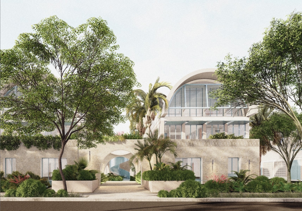
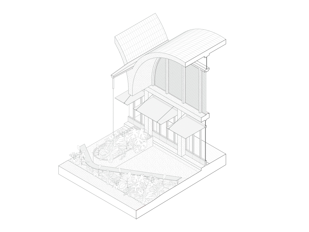
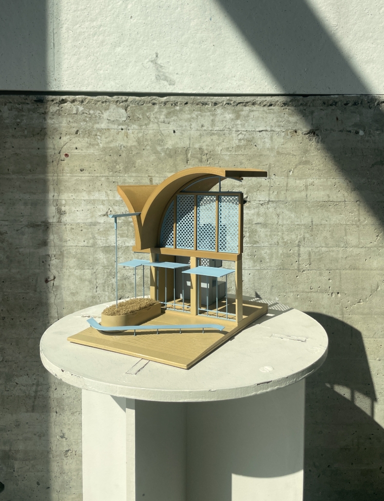
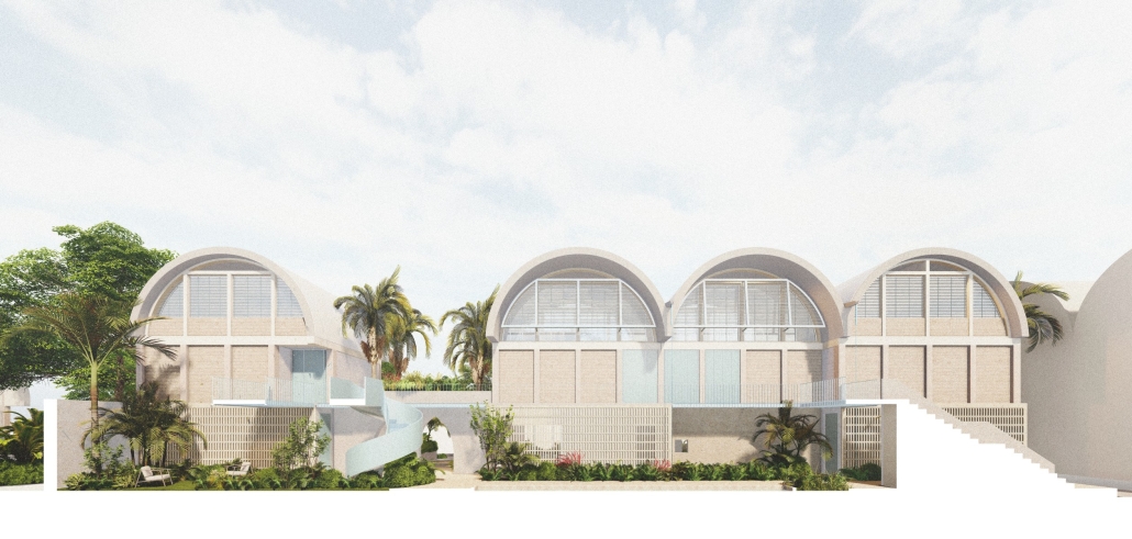
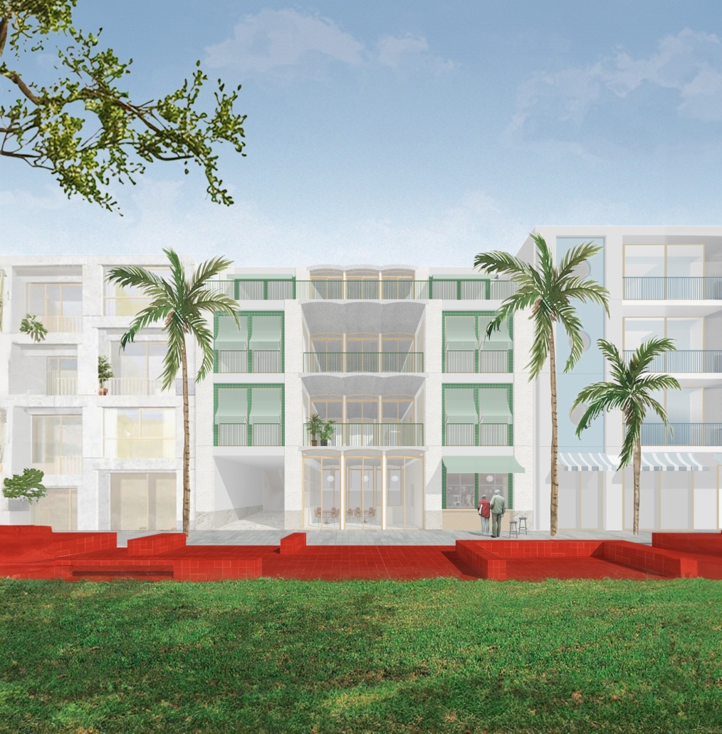
Housing in Miami primarily features two typologies: the single-family detached home and the multi-story apartment block. The large gaps in the housing market prompted our studio to explore alternative solutions by imagining new housing typologies. Our project finds a middle ground, envisioning a mid-density housing typology inspired by the back bay townhouse and influenced by the “casa patio”—a traditional housing style of Latin America.
The studio selected a 30-acre site located between Little Havana and Flagami. This site presented a tabula rasa condition which allowed us to rethink urbanism for these new typologies. Our design extends the Miami grid to integrate the site into the city while halving the typical Miami lot width from 50′ to 25′. This increased density facilitated the inclusion of a public park in the center of the lot, achieving greater density than typical Miami blocks. We envisioned urbanism as incremental, with each block functioning as a micro-neighborhood that could be built by small developers, thereby supporting incremental urbanism in the city. The arrangement of the block also decreases overall parking space while ensuring at least one parking spot per unit.
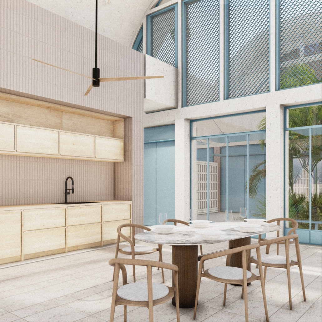
Within the block, we proposed two distinct housing typologies to foster diversity in sizes, ages, and incomes: a townhouse and an apartment building. The townhouse layout includes two areas: one for living, kitchen, and dining, and another for bedrooms and support spaces, connected by a courtyard. This design allows for cross-ventilation and access to nature. While designed for mechanical ventilation, the architecture encourages the use of passive systems for most of the year. The units are constructed using local materials and techniques, such as concrete block, precast vaults, tile, metalwork, and keystone. Emphasis on material and vegetation ensured a connection to the weather, nature, and culture of Miami.
The apartment block adapts features from the townhouse, tailored for communal living. The 25′ lot width remains consistent, with the townhouse elevated into a podium. This configuration creates six apartments on the first floor and six double-height apartments above, ranging from studios to three-bedroom units. The courtyard, featuring a water element and lush vegetation, provides a communal gathering space that ensures cross-ventilation while maintaining privacy for residents.
This project was published in Retrospecta 47.
Instagram: @fptrujillo, @nicoleniava, @cureandpenabad
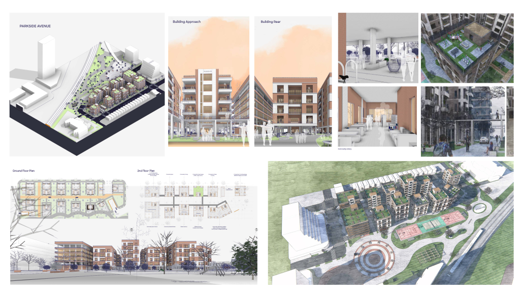
Parkside Avenue: Transforming Toronto’s Mid-Central Residential Neighbourhood by Oluwatobiloba Babalola Oluwaseun, M. Arch ’24
University of Waterloo | Advisors: Val Rynnimeri & Samantha Eby
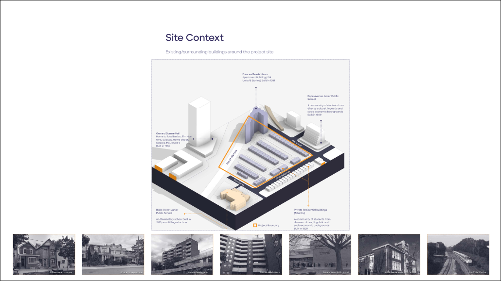
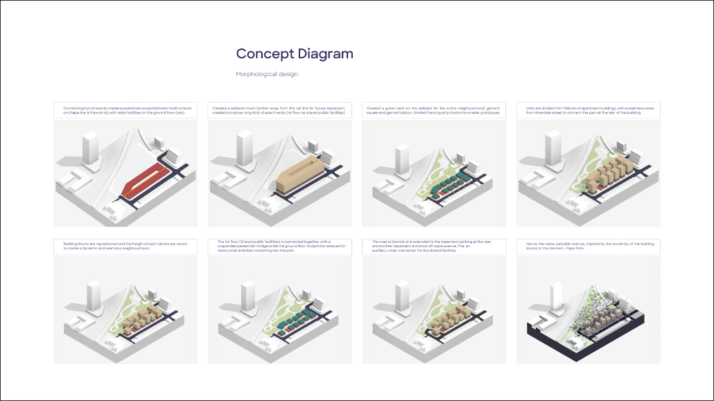
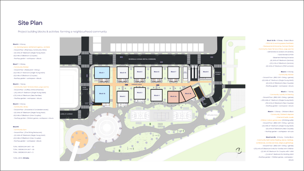
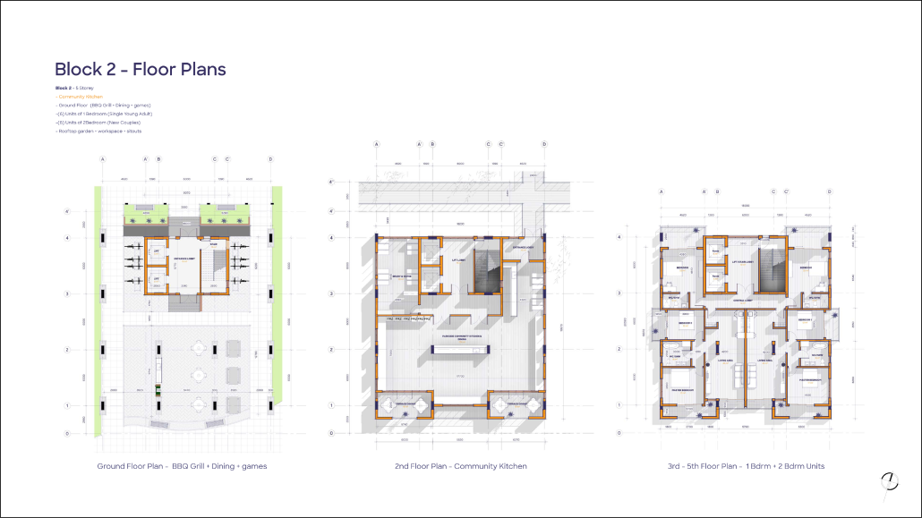
The Parkside Avenue project addresses critical housing issues in Toronto’s mid-central residential neighborhoods, particularly within the “Yellow Belt,” known for its older single-family homes. This initiative aims to create a balanced urban solution that integrates market-based residential buildings with non-profit cooperative housing and other alternative models. The primary objective is to enhance housing affordability and mitigate the shortage of affordable housing options in the area.
Located between Pape Avenue and Gerrard Street, the project site encompasses approximately 50 private single-family homes. Its strategic location, near the high-traffic Gerrard Station and adjacent to Blake Street Junior School and Pape Avenue Junior School, makes it a prime area for redevelopment. The Parkside Avenue project plans to replace the existing 50 single-family units with 109 new residential units.
This development represents a significant shift in urban planning for the neighborhood, aiming to accommodate a diverse range of residents and provide more inclusive housing solutions. By integrating various housing types and focusing on affordability, the project seeks to foster a more vibrant, sustainable, and accessible community. The Parkside Avenue project stands as a model for addressing urban housing challenges while preserving the character and livability of Toronto’s established neighborhoods.
This project won the Design Studio Award, the Highest standing in ARCH 690 in the MB semester.
Instagram: @oluwatobilobababalola_
The Room is the Building is the City: Open-Ended Approach to Miami’s Housing Crisis by Sharona Cramer & Yotam Oron, M. Arch ’24
Yale University | Advisors: Adib Cúre, Carie Penabad & Deborah Garcia
Introduction (The Site, the Brief, and Our Approach):
Miami, currently the most unaffordable major city in America, faces a housing crisis with limited and unsuitable options for its growing needs. The city is dominated by detached single-family homes and high-rise condos, contributing to suburban sprawl and high land costs. Mid-rise housing models, offering innovative urban living solutions, have been largely overlooked.
The studio’s task was twofold: to propose a master plan for a 38-acre vacant parcel on the outskirts of Little Havana, addressing Miami’s urban morphology, and to design a new mid-rise urban housing typology for Miami, featuring mixed-use buildings with commercial/office spaces at ground level and various apartment types above.
To tackle these issues, which characterize Miami but are not limited to, the project operates at a wide range of scales, from the single room to the urban fabric, promoting an approach of open-ended locality. This combines consideration of climate, materiality, culture, and economy with flexible, rational, and modular architectural solutions.
The City:
Due to its limitations and restrictions, Miami’s current zoning, led by its parking regulation, makes building complicated and expensive. The market lacks competition, which makes housing unaffordable and attracts mainly big developers, prioritizing profit-making over building and architectural quality. The typical development project is done by conglomerating lots to develop ‘luxurious’ huge-scale anti-urban and anti-social residential compounds.
By suggesting a much more flexible and open alternative zoning system and limiting the conglomeration of lots, the project seeks to invite multiple players to participate in the city’s future development, creating quality, affordable, and diverse urban spaces and housing stock.
Additionally, the project proposes a series of site-specific design decisions: To connect the site to Miami’s urban fabric, we decided to continue the grid through the site and divide it into urban blocks similar in size to the adjacent blocks, then divide each block into lots in the typical Miami lot size: 50* 100 feet. Learning from successful urban spaces in the city, we propose a series of pedestrian streets and a linear park connecting all blocks from south to north.
The Building:
In the project, we developed a mid-rise courtyard infill type. While the flexible zoning system allows multiple typologies, we chose to develop an infill building since Miami currently lacks this type. Furthermore, we believe that infill typologies offer potential in terms of high density, and the sort of streets they generate.
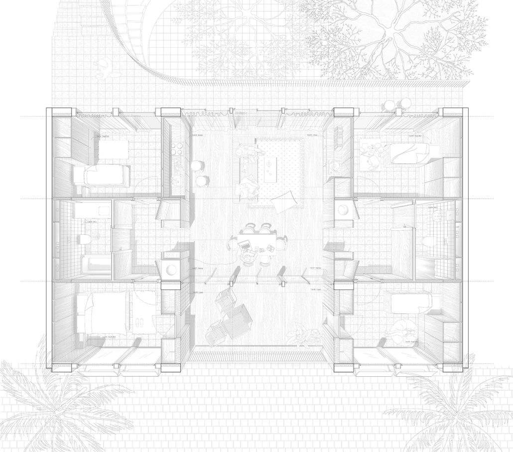
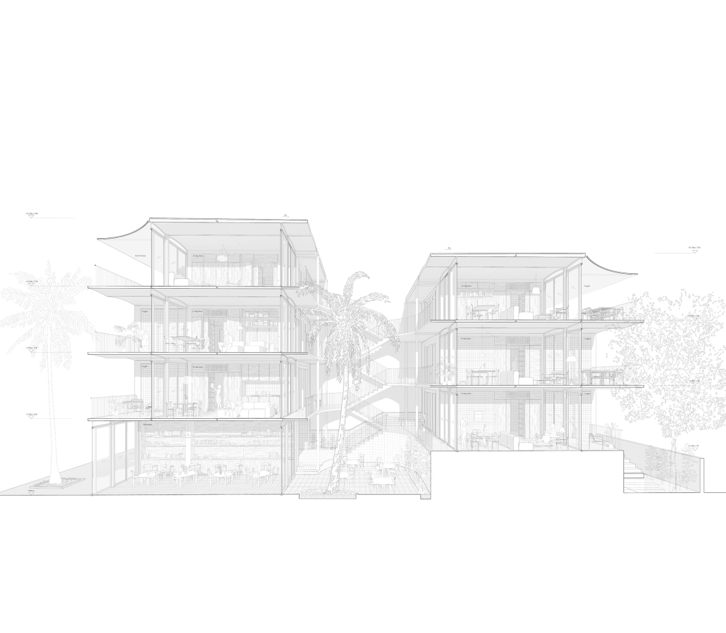
Inspired by similar typologies like the Berlin courtyard houses, the Mexican Vecindad, and the Creole townhouses, we created a local interpretation that reacts to the regional tropical climate and contemporary Miami standards. On one single lot, two relatively thin volumes are positioned, leaving a space for a central courtyard. The interior rooms, which have two orientations, are cross-ventilated and naturally cooled.
The building is designed using repetitive modules, thus increasing affordability and efficiency, making it easy to construct. Through sensitivity to details, use of materials, and small, subtle architectural gestures, these are realized without sacrificing architectural and spatial quality.
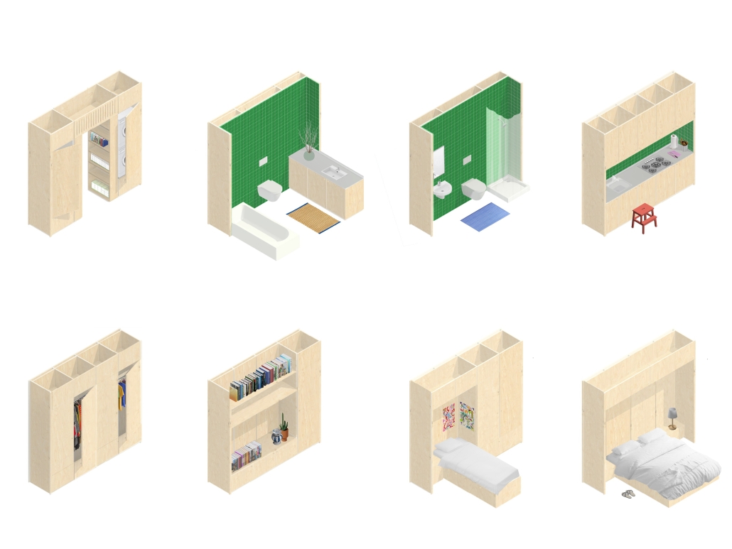
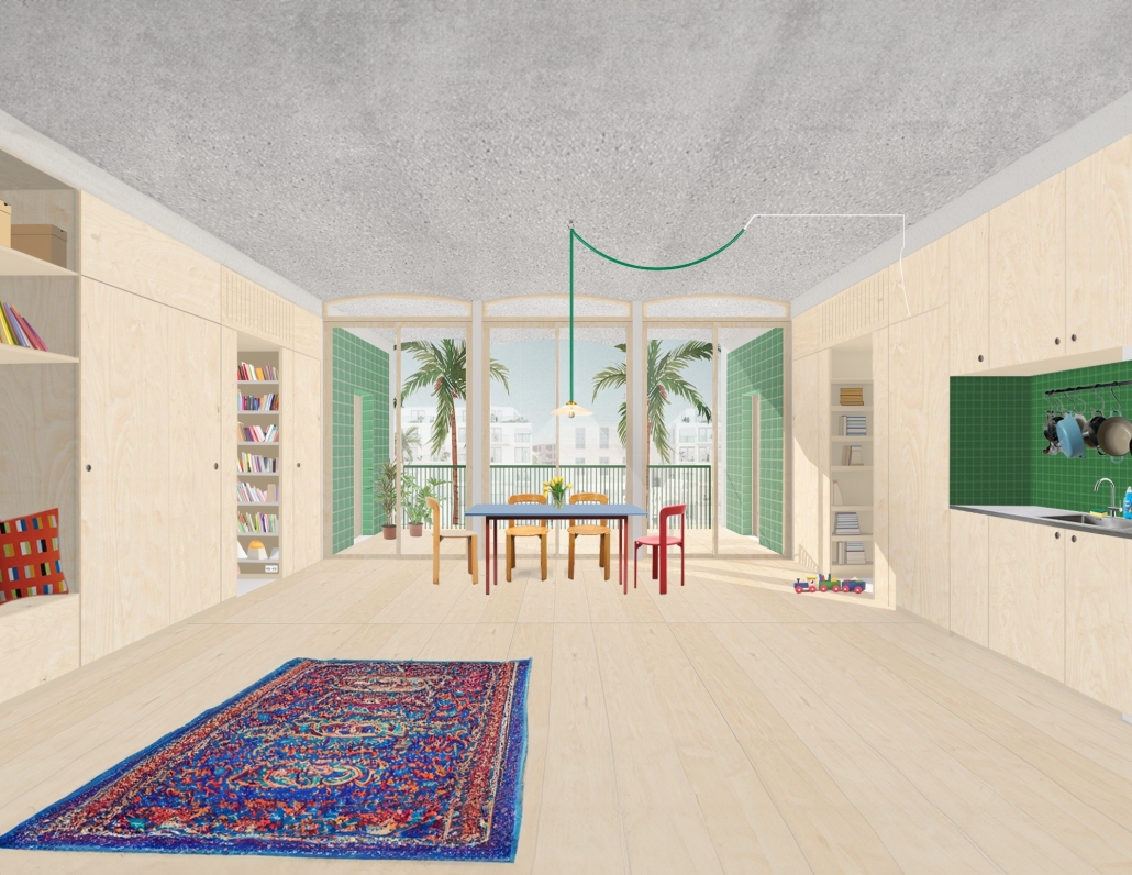
The building is divided into two distinct sections: “service” wings; housing private rooms, and an open flexible central “served” space. These sections are treated differently in terms of materials and construction techniques. The service wings hold all systems, structures, and storage, allowing the central area to remain free of these elements. This central space features light concrete precast vaulted slabs, which give the building its unique architectural character. The thicker floor sections in the service wings provide flexibility for plumbing fixtures, enabling them to drain through the floors to the vertical pipes that are located along the party walls – maximizing flexibility and allowing multiple apartment layouts.
The Room:
Instead of conventional drywall partitions, the project incorporates a modular furniture system that maximizes usable open space and provides flexibility. These modules can serve as walls, partitions, storage spaces, or even house plumbing fixtures. The variety and placement of these modules enable different floor plan configurations, allowing the housing units to be divided into two separate units—a main apartment and a studio—or to modify the internal layout of the apartment itself.
The central open living space is designed to respond to and take advantage of the local tropical climate. Drawing inspiration from traditional and vernacular tropical architecture, deep loggias and shaders provide protection from the harsh sun during certain hours, while also serving as outdoor rooms that integrate the outdoors into daily life. The central living space opens up to the loggias, creating a cross-ventilated indoor-outdoor environment.
This project was Nominated for the Feldman Prize at Yale School of Architecture.
Morphological Growth of Raleigh by Raja Manikam Bandari, M. Arch, PhD in Design Candidate ’24
North Carolina State University | Advisors: Sara Queen & Tania Allen
Across the US, we are witnessing a housing crisis catalyzed by a pandemic-related housing shortage and exaggerated by income inequality resulting in a disproportionate burden on the poor and non-homeowners. This visual essay examines historic and contemporary data to interrogate many of the complex factors that have contributed to the current state of housing in Raleigh, the Triangle, North Carolina, and the US. The primary aim of this research is to create more equitable, effective and innovative design and planning approaches to the future of housing and urban development writ large.
Spatial Morphology (1)
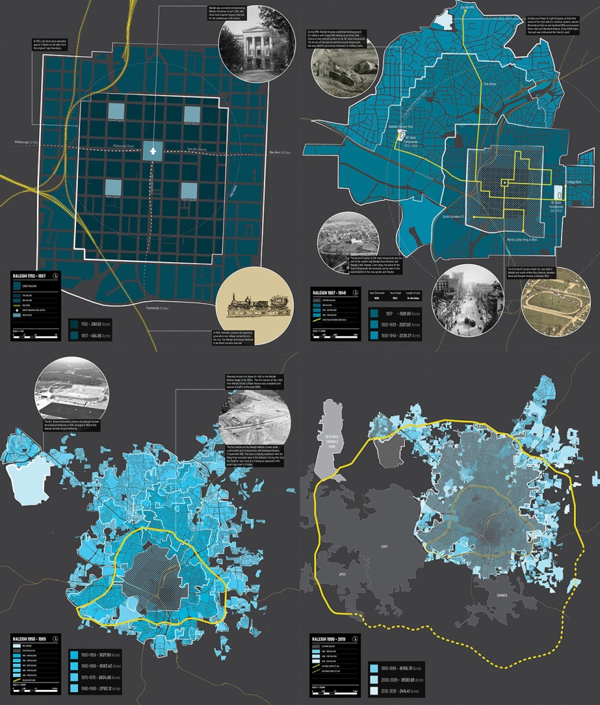
This map series charts Raleigh’s historical expansion, tracing how the city’s footprint has expanded over time. Historical context illuminates pivotal moments of growth and development, showcasing the transformation of rural landscapes into urban areas and residential neighborhoods.
Temporal Morphology of Raleigh (2)
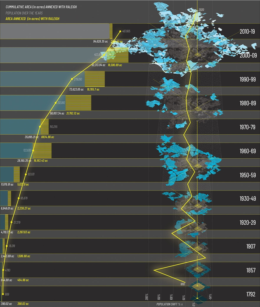
This map illustrates the city’s expansion over time, showcasing the interplay between population influx and territorial expansion. Since its master planning by William Christmas in 1792, Raleigh has undergone significant transformation driven by diverse factors such as commerce, education, trade and natural opportunities. This timeline serves as a chronological thread, connecting historical milestones with the city’s expanding boundaries and changing demographics.
Proximity Growth Analysis of Raleigh (3)
This map reveals a detailed analysis of Raleigh’s morphological growth pattern from 1792 to 2019 through proximity radar charts centered on the State Capitol Building which tracks annexed lands in relation to the city’s geographical center. Each radar chart depicts the distance in miles between the State Capitol and annexed parcels of land during a specific time period. The central graph illustrates the cumulative annexations over time.
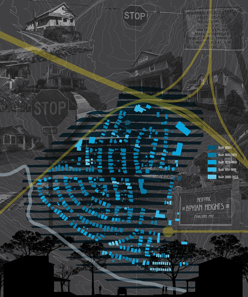
Morphological Growth of Boylan Heights (4)
This map offers an intimate exploration of the morphological characteristics and unique layout of Boylan Heights, a neighborhood distinguished by its sloping topography and curvilinear street design. Situated on elevated terrain, Boylan Heights descends gradually from its highest point at Montfort Hall towards the east, south and west directions. Unlike the traditional right-angle grid common in earlier Raleigh developments, Boylan Heights features the city’s first curvilinear street grid, designed to harmonize with the natural slope of the land.
This project was selected as a finalist for the APDU Data Story Telling Award, AIA ASPIRE Student Design Award, and NC State Research Image Award.
Instagram: @raja_manikam_brv, @tanialeighallen, @rainrainqueen
Zoning Policy & Housing by Kole Retterath, B. Arch ’24
North Carolina State University | Advisors: Sara Queen & Tania Allen
Across the US, we are witnessing a housing crisis catalyzed by a pandemic-related housing shortage and exaggerated by income inequality resulting in a disproportionate burden on the poor and non-homeowners. This visual essay examines historic and contemporary data to interrogate many of the complex factors that have contributed to the current state of housing in Raleigh, the Triangle, North Carolina, and the US. The primary aim of this research is to create more equitable, effective and innovative design and planning approaches to the future of housing and urban development writ large.
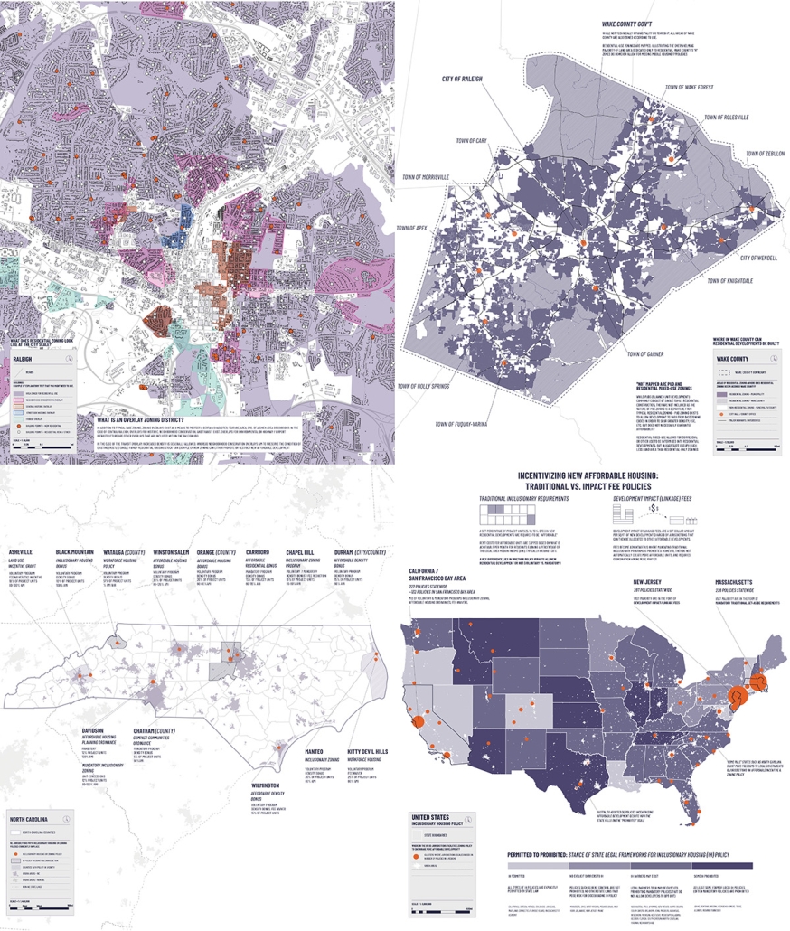
Zoning and Affordability Incentives (1)
This map series explores the influential forces of zoning and affordable development policies on the current housing crisis. Zoning has major implications for cost, availability and affordability by indirectly impacting the supply and demand of housing stock. By highlighting how restrictive zoning policies historically privileged single-family typologies and reduced the opportunity for diverse affordable housing units, these maps illustrate how we have arrived at our current “Missing Middle” condition.
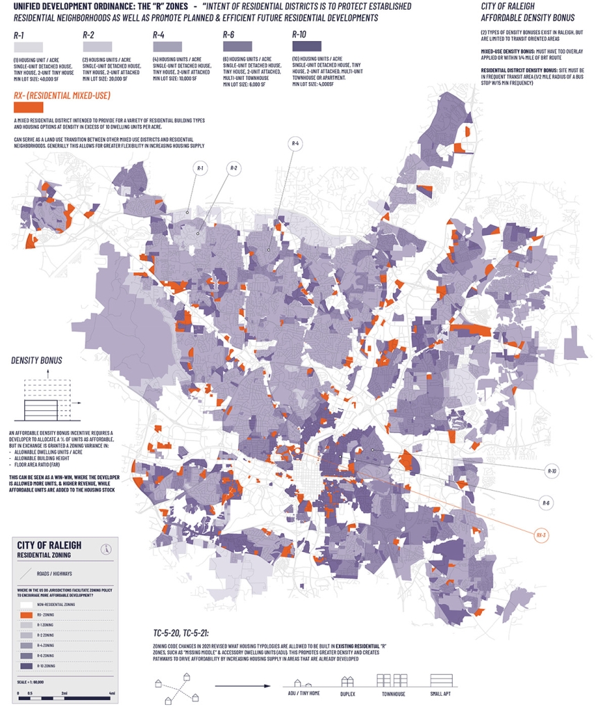
Residential Zoning in Raleigh (2)
This map isolates residential zoning categories and illustrates the dominance of residential single-family zoning (R-1 to R-10) in a purple gradient in contrast to the emerging pockets of residential mixed-use zoning (RX) in orange. The white negative space of the map indicates large institutional footprints and transportation corridors with industrial and commercial land uses.
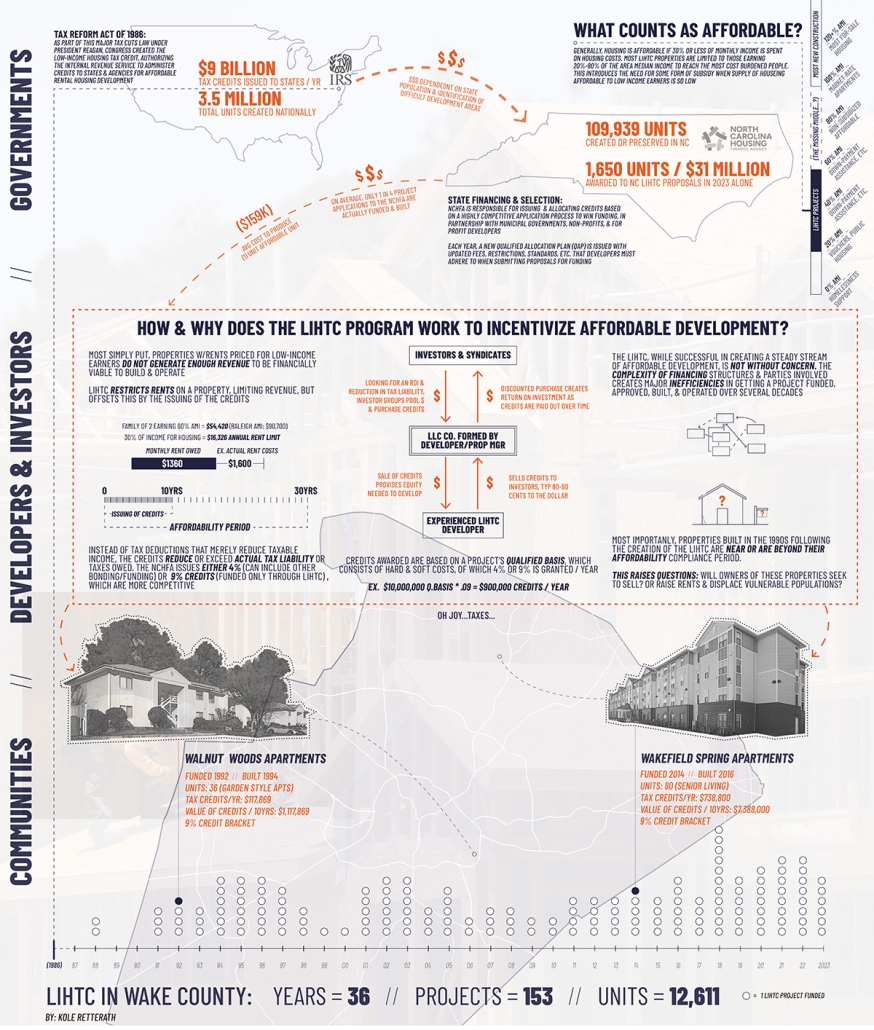
Understanding the Low-Income Housing Tax Credit (3)
This map visualizes all LIHTC projects in Raleigh and their respective values. Created in 1986, LIHTC is a method of financing rental unit development that caps rent amounts in exchange for equity-building tax credits. LIHTC remains one of the most important tools to finance affordable rental units, but drawbacks include that rent amounts are not permanently capped and very low-income renters often still require assistance to pay rent.
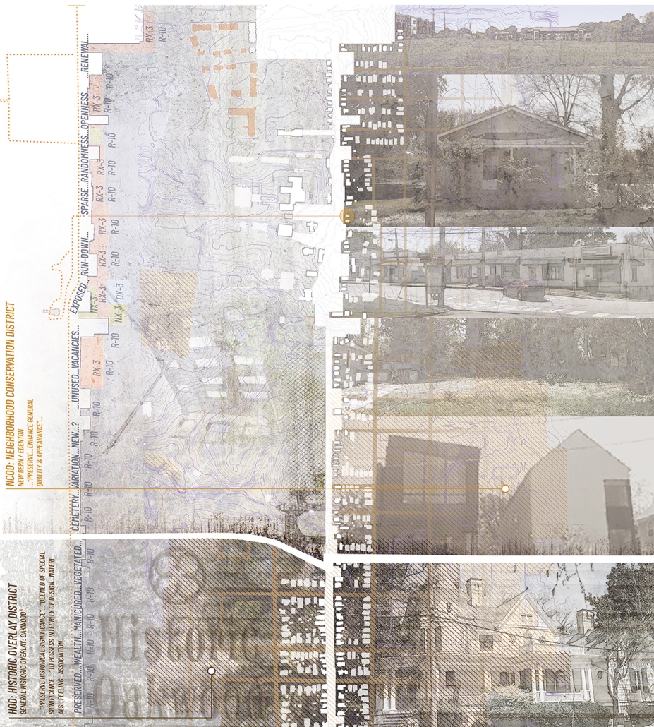
Perceptions of Zoning Policy: Oakwood Ave (4)
This perceptual collage depicts the diverse conditions along Oakwood Avenue which runs east-west from College Park and Washington Terrace neighborhoods to the Historic Oakwood neighborhood and exemplifies the impact of zoning overlay districts and preservation incentives in appearance and investment.
This project was selected as a finalist for the APDU Data Storytelling National Award, AIA ASPIRE Regional Student Design Award, and NC State Research Image Award.
Instagram: @tanialeighallen, @rainrainqueen
Homeownership & Economic Prosperity by Dillon Patel, B. Arch ’24
North Carolina State University | Advisors: Sara Queen & Tania Allen
Across the US, we are witnessing a housing crisis catalyzed by a pandemic-related housing shortage and exaggerated by income inequality resulting in a disproportionate burden on the poor and non-homeowners. This visual essay examines historic and contemporary data to interrogate many of the complex factors that have contributed to the current state of housing in Raleigh, the Triangle, North Carolina, and the US. The primary aim of this research is to create more equitable, effective and innovative design and planning approaches to the future of housing and urban development writ large.
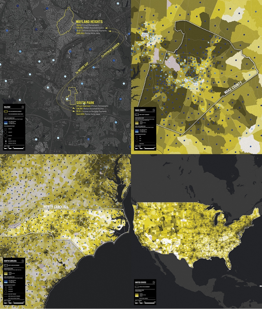
Homeownership, Median Income and Urbanity (1)
This map series highlights the intricate relationship between homeownership rates and median income levels at four different scales. Nationally, urban areas are concentrated alongside major infrastructure, enhancing economic prospects. In NC, rural regions exhibit significantly higher homeownership rates, despite lower median incomes, compared to urban counterparts that attract higher incomes but fewer homeowners.
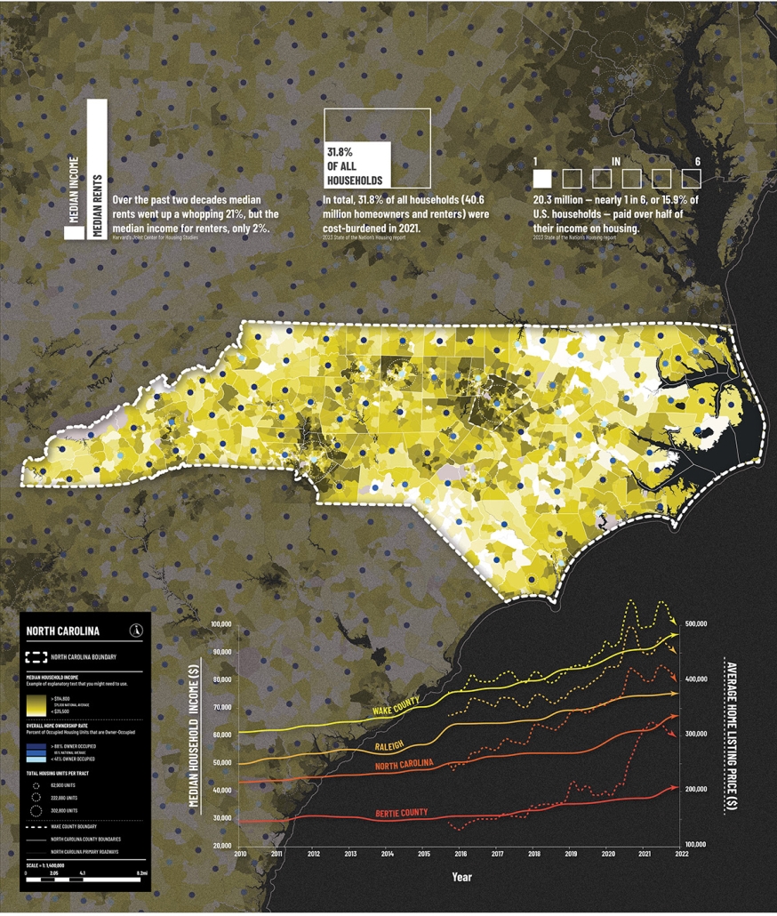
Median Income and Housing Affordability (2)
This map sheds light on contrasting economic landscapes within NC while highlighting the intricate interplay between income, housing costs, and the pursuit of homeownership. The graph traces the evolution of median incomes and average house listing prices to underscore the stark economic disparities within the state. It reveals Wake County as an apex of economic and housing market vitality as compared to Raleigh, the broader state, and Bertie County.
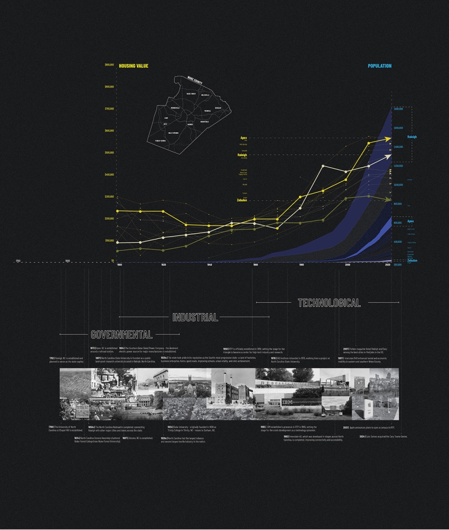
A History of Economic Disparities In Wake County NC (3)
This timeline charts how Wake County’s economic vibrancy stems from the distinct developmental patterns of its towns and the surrounding counties. Western Wake towns and cities have remained ahead of eastern towns due to the western-focused development toward the Research Triangle Park, Durham, and Chapel Hill. Average housing values are higher in western towns and cities of Wake County, and these are correlated with higher population counts and higher median income levels.
Old Roots, New Rises: Transitions of Architecture (4)
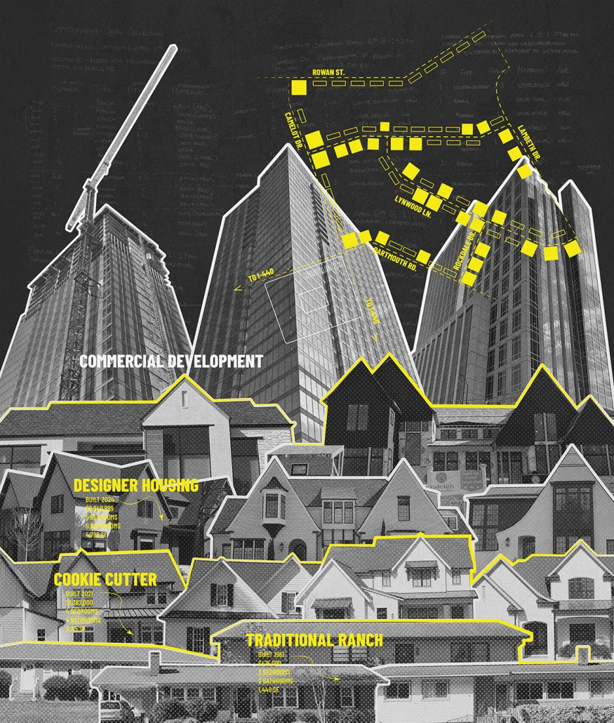
This investigative, on-the-ground mapping project delves into the architectural transformations in Raleigh’s Farrier Hills and Lakemont neighborhoods by documenting the evolution from traditional ranch-style homes to modern, multi-story residences, reflecting a complex interplay of tradition and modernization.”
This project was selected as a finalist for the APDU Data Storytelling National Award, AIA ASPIRE Regional Student Design Award, and NC State Research Image Award.
Instagram: @dilpickle01, @tanialeighallen, @rainrainqueen
Growth & Vulnerability by Gabrielle Schiltz, B. Arch ’24
North Carolina State University | Advisors: Sara Queen & Tania Allen
Across the US, we are witnessing a housing crisis catalyzed by a pandemic-related housing shortage and exaggerated by income inequality resulting in a disproportionate burden on the poor and non-homeowners. This visual essay examines historic and contemporary data to interrogate many of the complex factors that have contributed to the current state of housing in Raleigh, the Triangle, North Carolina, and the US. The primary aim of this research is to create more equitable, effective and innovative design and planning approaches to the future of housing and urban development writ large.
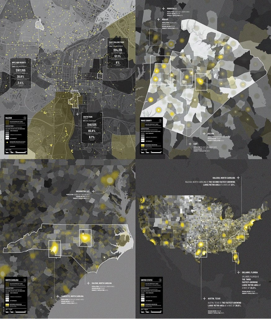
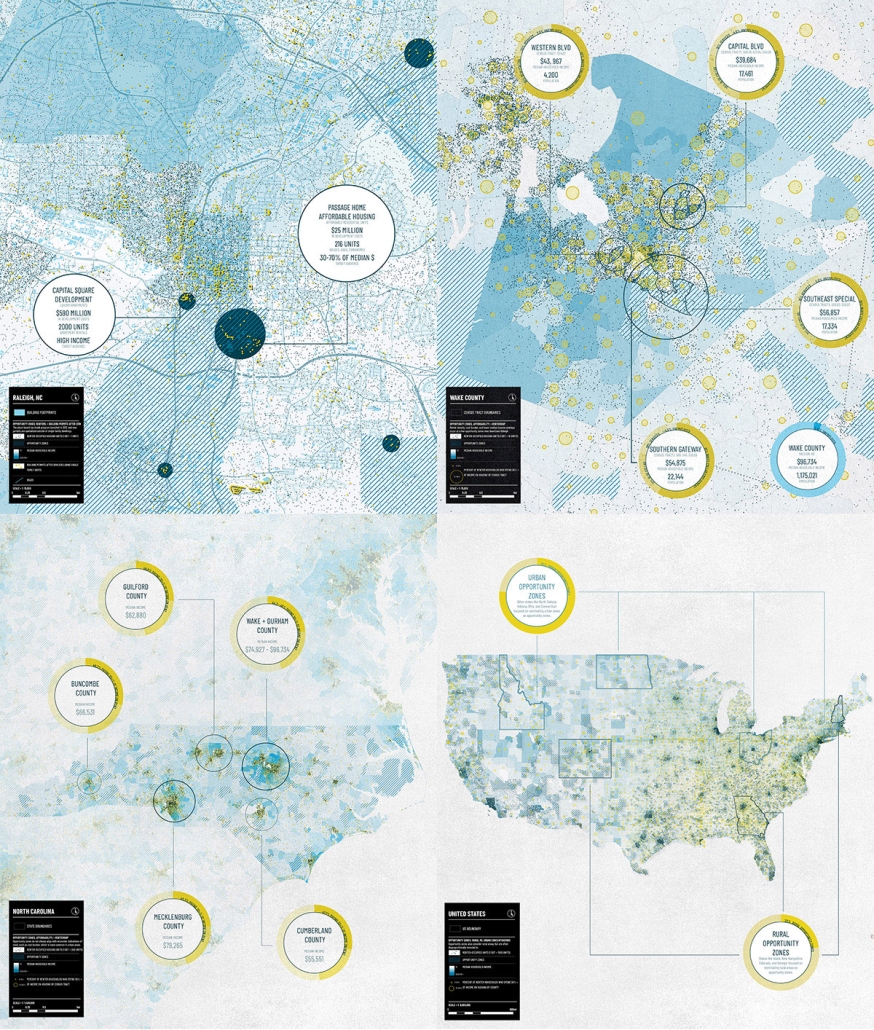
Growth & Vulnerability: Examining Development and Marginalized Groups (1)
This map series explores the complex relationship between redevelopment and marginalized communities. The concentration of recent building permits and opportunity zones illustrates foreseeable development with loose correlative patterns between growth and marginalized populations.
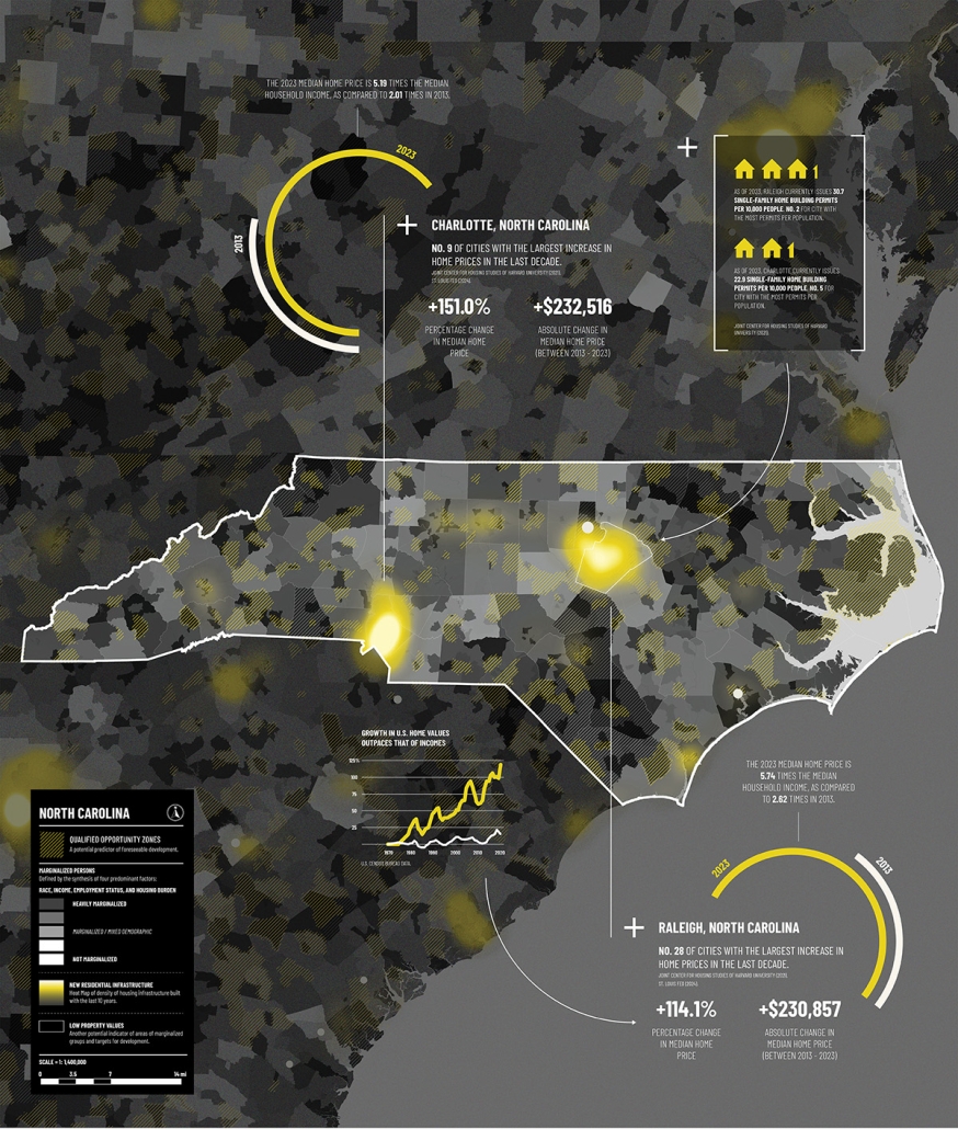
Growth & Vulnerability: The Disproportionate Rise of Housing Prices (2)
This map explores the potential correlation between residential development and marginalized demographics, questioning if historical patterns persist or are becoming increasingly obsolete. There are many factors that determine if a population is considered marginalized, prime factors articulated through this series include race, income, employment status, and housing burden.
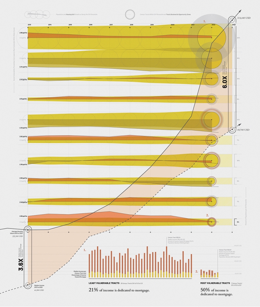
Growth & Vulnerability: A Study of Housing Flux Within Wake County (3)
This visualization explores the relationship between population density, housing unit density and population growth within socially vulnerable communities using the CDC’s Socioeconomic Vulnerability Index (SVI). The map categorizes Census Tracts per SVI percentile with the least vulnerable census tracts at the top and the most vulnerable tracks at the bottom. Each string articulates the population and housing unit growth or decline from left to right.
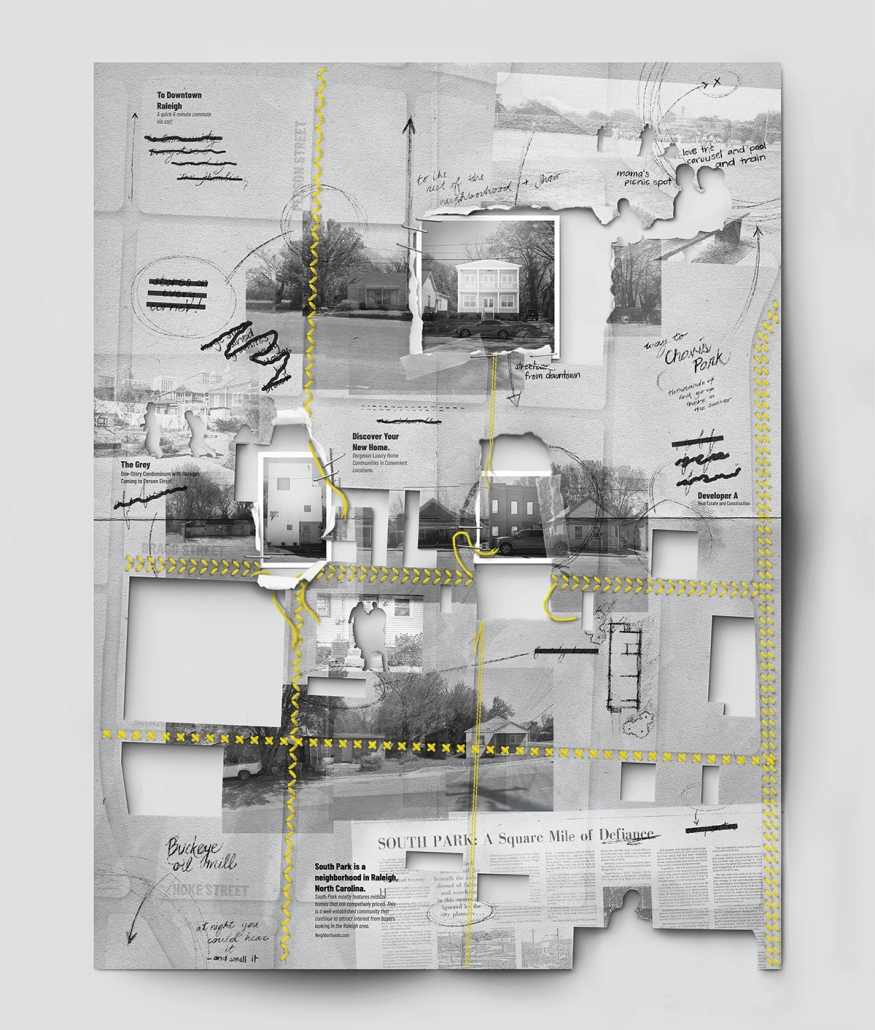
Growth & Vulnerability: Erasure of Neighborhood Identity: South Park (4)
This map offers a human-centric counter-narrative to the statistical analysis of redevelopment featured in earlier maps and considers: Who is represented within neighborhood data and how do their lives weave into the greater tapestry of the community? The map illustrates the in-progress erasure of South Park’s historically rooted identities due to contemporary redevelopment patterns.
This project was selected as a finalist for the APDU Data Storytelling National Award, AIA ASPIRE Regional Student Design Award, and NC State Research Image Award.
Instagram: @gabrielle.schiltz, @tanialeighallen, @rainrainqueen
Are Opportunity Zones Helping or Hurting? by Maggie Kroening, B. Arch ’24
North Carolina State University | Advisors: Sara Queen & Tania Allen
Across the US, we are witnessing a housing crisis catalyzed by a pandemic-related housing shortage and exaggerated by income inequality resulting in a disproportionate burden on the poor and non-homeowners. This visual essay examines historic and contemporary data to interrogate many of the complex factors that have contributed to the current state of housing in Raleigh, the Triangle, North Carolina, and the US. The primary aim of this research is to create more equitable, effective and innovative design and planning approaches to the future of housing and urban development writ large.
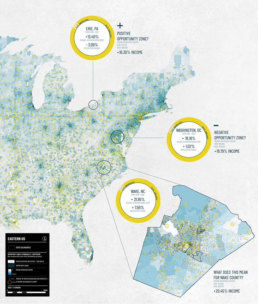
Examining Income and Rentership within OZs (1)
This map series looks at the impact of Opportunity Zone designations on neighborhood displacement and overall housing burden. Signed into law by the 2017 Tax Cuts and Jobs Act, Opportunity Zones (OZs) were originally launched as a place-based tax credit to encourage investment in impoverished communities, but have since faced a large degree of controversy.
Are Ozs Helping or Hurting? (2)
This map features two contrasting cases, Erie, PA and Washington DC, exemplify the debate around OZs. US Treasury analysis reveals that 48% of zones do attract investment, but funds are often concentrated in isolated fractions of the whole zone. According to the NLIHC, targeted OZs often experience economic growth and renter displacement prior to investment. For Wake County, tracking OZ developments is crucial to examine who they serve and if they are contributing to equitable development.
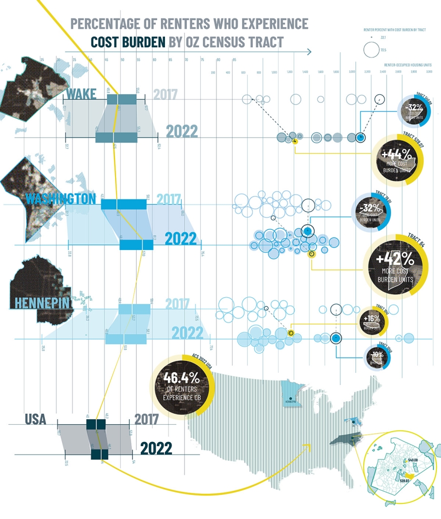
Renter Cost Burden in OZs (3)
This map highlights change in rates of rent cost burden within OZs from three disparate countries, Wake (Raleigh), Washington DC, and Hennepin (Minneapolis), from 2017 to 2022 through box plots and beeswarm visualizations. The most extreme cases of either an increase or decrease of cost burden within each county are shown by tract.
Delineating the Fringe: OZs and Housing (4)
This map records observations of the Southern Gateway OZ along the Lake Wheeler corridor in Raleigh NC. Within a half mile three extremes of housing conditions were observed: new high-rise apartments, existing single-family homes, and people experiencing homelessness. This map raises complex questions concerning the impacts and opportunities of increased density and redevelopment fueled by OZs.
This project was selected as a finalist for the APDU Data Storytelling National Award, AIA ASPIRE Regional Student Design Award, and NC State Research Image Award.
Instagram: @maggie.k, @tanialeighallen, @rainrainqueen
Predatory Development by Lucas Stott, B. Arch ’24
North Carolina State University | Advisors: Sara Queen & Tania Allen
Across the US, we are witnessing a housing crisis catalyzed by a pandemic-related housing shortage and exaggerated by income inequality resulting in a disproportionate burden on the poor and non-homeowners. This visual essay examines historic and contemporary data to interrogate many of the complex factors that have contributed to the current state of housing in Raleigh, the Triangle, North Carolina, and the US. The primary aim of this research is to create more equitable, effective and innovative design and planning approaches to the future of housing and urban development writ large.
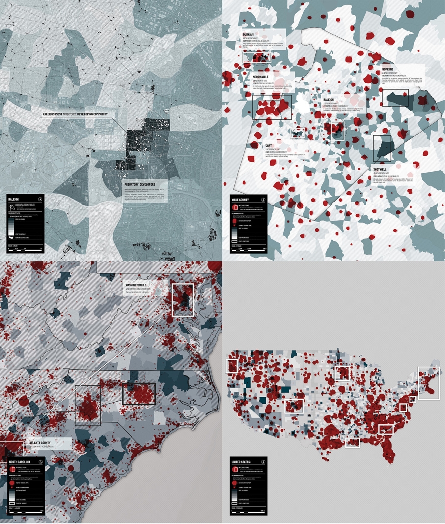
What Makes a Neighborhood Vulnerable? (1)
This map series illustrates markers for housing vulnerability (race, housing burden, age, and occupancy status) to identify tracts as more/less vulnerable. These measures of vulnerability are overlaid with measures of population growth and the areas of overlap suggest the neighborhoods most vulnerable to the threats of gentrification.
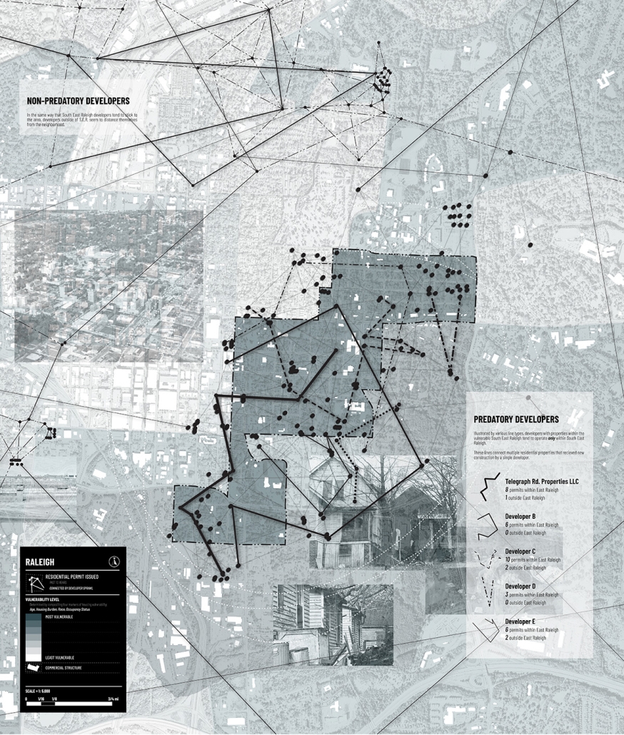
Predatory Development (2)
This map visualized patterns of redevelopment in Southeast Raleigh which has historically had low-income residents and under-valued properties. By plotting building permit data, we see a distinct pattern of developers active solely within Southeast Raleigh versus developers that avoid it completely.
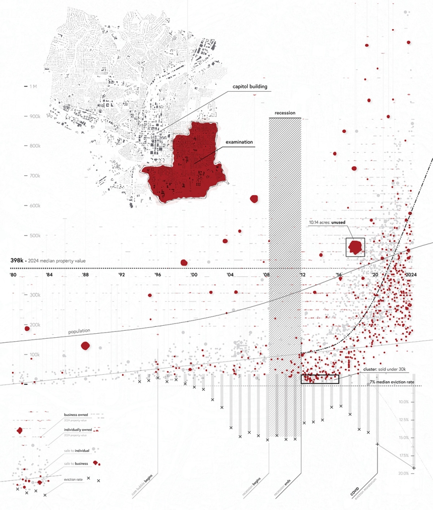
Speculative Real Estate and Community Vitality (3)
This graphic aims to raise questions about the ethics of modern-day, speculative property sales. Southeast Raleigh, a region with high housing vulnerability, has seen drastic changes in the ownership and popularity of its land. Over time it transformed from an affordable, black neighborhood into a threatened historic district torn apart by redevelopment, rising housing costs, and speculative real estate.
Urban Squeeze: The Weight of Gentrification (4)
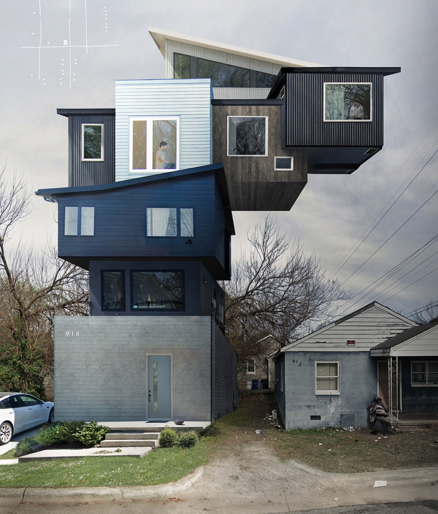
Walking through the South Park neighborhoods reveals a shift from shotgun houses and net-less basketball hoops to two-story contemporary houses flanked by Teslas and neon playgrounds. At this map’s core is a weather-worn, dilapidated house—a relic of South Park’s past and a poignant symbol of the challenges faced by its residents. Street photographs of recently constructed housing developments, all within 500 feet, are meticulously collaged to convey the experience of ongoing social suffocation and displacement.
This project was selected as a finalist for the APDU Data Storytelling National Award, AIA ASPIRE Regional Student Design Award, and NC State Research Image Award.
Instagram: @tanialeighallen, @rainrainqueen
Live, Laugh Learn: Affordable Housing in Honolulu by Marco Zhou, B. Arch ’24
California State Polytechnic University, Pomona | Advisor: Pablo La Roche
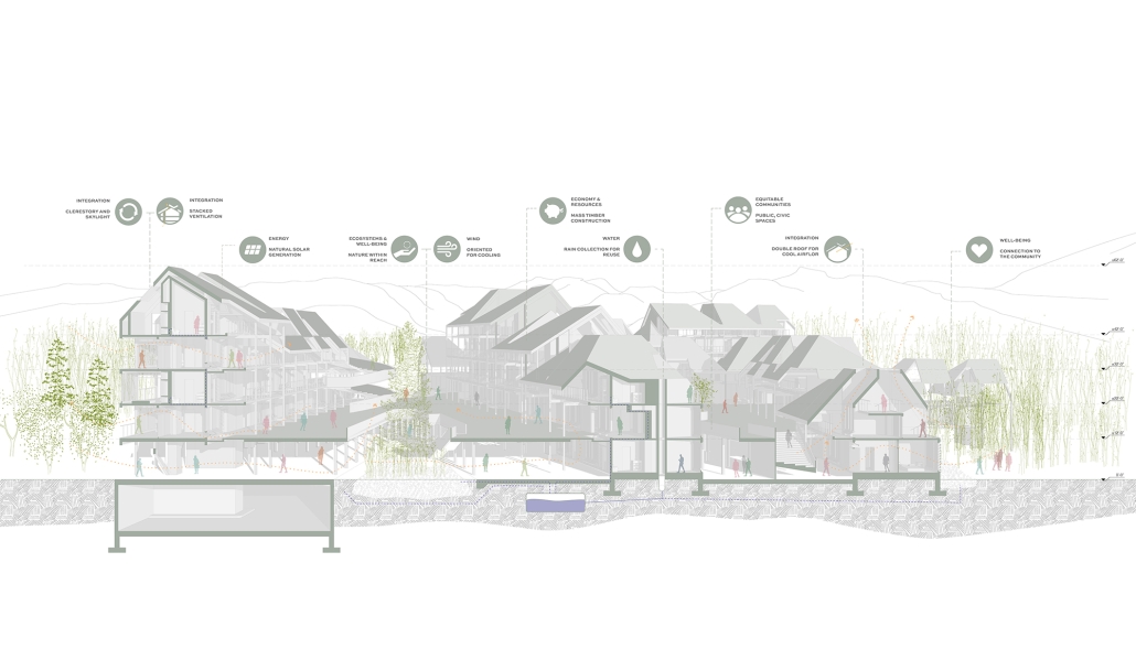
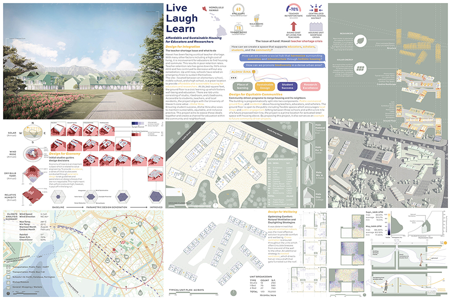
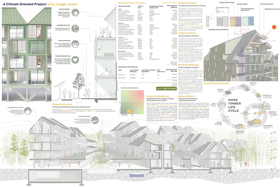
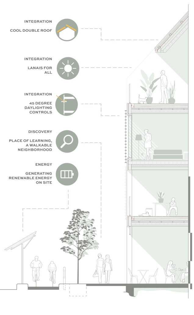
Live Laugh Learn is a sustainable affordable housing project in Honolulu to provide housing for educators and researchers. Due to the high cost of living in Hawaii, there are poor retention rates for teachers, and schools rely on emergency hires. This project, located between an elementary, middle, and high school, provides an option to alleviate this issue. There are 120 units, and the ground floor fosters well-being and education. The project also aligns with the University of Hawaii’s core value, Aloha “Aina. The project aims to create a social hub that harmonizes surrounding amenities and infrastructure, promoting biodiversity in a dense urban area. AIA’s COTE framework for design excellence was integrated into the design. Energy modeling and carbon calculations were an integral part of the design process from the beginning.
Instagram: @marcozhou_, @pmlaroche
Interested in being featured in next year’s showcase? Stay tuned for updates this summer!

