2023 Study Architecture Student Showcase - Part I
Welcome back to the Study Architecture Student Showcase fall series!
We put out a call over the summer for student work and received a record number of submissions – thank you to everyone who participated. With the Fall semester in full gear, we are excited to share the most outstanding projects with you over the next few months. To give you an insight into what it is like to study architecture, we will take a closer look at student thesis and capstone work from 2023.
Throughout the Student Showcase series, we will feature work from recent graduates of ACSA member schools from across the globe. These projects will highlight an array of topics and explorations, ranging from building designs focused on women empowerment or climate change to research on biomaterials and much more. Tune in every week for a new installment focused on a specific topic.
This week we take a look at projects that are aimed at combatting the issue of flooding, which we are seeing rise in frequency across the globe. In the last few weeks alone, we have seen extreme examples of just how damaging floods can be. The work below focus on how we can improve the flood protection process.


Urban Flooding Reuse for Addis Ababa (Ethopia) by Michael Clifton, B.Arch ’23
Tulane University | Advisor: Ruben Garcia-Rubio
The Urban Flooding Reuse Proposal is intended to create a way for residents of the river meander to live with and reuse flood water for their own benefit. This is a response to a high population of Addis Ababa’s (Ethiopia) residents living in highly vulnerable areas to flooding and a high amount of housing being built from weaker materials like mud and wood. These two problems that exist in the city lead to dangerous living conditions with flooding in a city that experiences plenty of rain and flooding yearly—and is projected to see much more in the future due to climate change.


Creative Triggering by Christine Chen, Meichen Duan, Ji Hyun Hwang, Jing Kang, Hong Ke, Wanshan Li, Zhe Li, Xinru Liu, Hoi Yau Lo, Ankita Mallick, Weixuan Wang, Ruijie Zhang, Wenhao Zhang, M. Arch ’23
University of Melbourne | Advisor: Justyna Karakiewicz & Theo Blankley
This studio takes the site of Australia’s largest major urban regeneration project – located at Melbourne, Fishermans Bend – which is over 480 hectares of land directly adjacent to the CBD. We propose the future of the precinct in light of ecological, environmental, structural and social changes across staged developments into the next century.
The Fishermans Bend precinct has its challenges. Much of it is threatened by flooding. A significant portion of the land is heavily contaminated by previous industrial users. We have learned that the quick fixes we often employ are based on misinterpreting symptoms for causes as we try to address current problems. We can observe that our quick interventions distract us from doing the deeper work needed that might lead to a better world for the planet, for all species and the environment, rather than just for the electorate.
By 2025, the Stage 1 will be completed and will feature large scale facilities for advanced manufacturing, fabrication, testing and prototyping with large scale collaborators such as the University of Melbourne, Boeing, Tesla, and others. By 2050, the Victorian Government proposes there will be 80,000 residents and employment for up to 80,000 people. Looking forward, we know that by 2100, much of Fishermans Bend could be under water, even under the most moderate predictions for sea level rises. We know that most of the surface soil is toxic. This combination of toxic land and flooding does not suggest that this is suitable place to live.
Combining Slow, Medium and Fast approaches, the propositions are illustrated by small, medium and large projects. These include two urban infrastructure strategies, and eight architectural projects.The works shown here illustrates an incremental development, with Stage 1 in 2025-2030, Stage 2 in 2030-2050, and Stage 3 in 2050-2100. Students worked collaboratively and developed programs and outcomes that interconnected and linked with each other – as evidenced in the final panels showing relationships between proposals and how one project may ‘trigger’ another.
Instagram: @msdsocial, @msd.gallery, @theoblankley, @meichend_, @lohoiyau, @ankitamallick,


BQE Hydrology Hub by Emma Mangels, B.Arch ’23
New York Institute of Technology | Advisor: Evan Shieh
The re-imagination of the Gowanus Canal aims to address the environmental and hydrological issues facing the Gowanus Canal at the local scale and the surrounding neighborhoods of Brooklyn at the borough scale. The Gowanus Canal and the surrounding neighborhood of Red Hook has been a highly-contested area due to the status of the waterway being declared a superfund site. As well as flooding occurring on the shoreline and also in-land which can be traced back to the out-dated combined sewer outflow system or CSO feeding into the canal.
To address this issue, a “Hydrology Hub” will be created at the crossing of the Brooklyn Queens Expressway (BQE) at the local scale to clean water in an efficient manner and reduce in-land flooding as well as making the water filtration process visible to the community. The hub will allow for people to follow the newly designed circular system of water filtration that uses both natural and man-made processes. The filtration circulation will bring the person down to the canal level where a walkable park will take over the current hard-edge of the canal. In order to protect the new in-land system, the borough scale will include the implementation of a soft shoreline to slow erosion and provide habitats for flora and fauna, creating a “kit of parts” to foster an environmentally resilient community while also placing an emphasis on circular systems of water.
Instagram: @mangels.arch, @ev07


Island Revitalization by Kelly Zheng, B.Arch ’23
New York Institute of Technology | Advisor: Farzana Gandhi
Coney Island is a peninsula that sits in the southern part of New York City. The site is a smaller scale of NYC that demonstrates the environmental problems that the city faces. It is an area full of residential structures and commercial businesses.
Coney Island suffers from bad air quality, urban heat, flooding, and poor water management, causing bad living quality and health risks. These issues should not be understood and treated separately. They are all part of a reciprocal ecosystem where one problem typically worsens another.
It is essential to develop a holistic and comprehensive integrated solution that makes Coney Island more livable today and far into the future. The proposal is inspired by such solutions found around the world and at multiple scales from masterplan to kiosks.
Coney Island was originally a collection of islands and shifting sand, with inlets connecting the islands during low tide periods. In the late 1700s, the sand-shifting movements closed the inlets, so the residents filled in the space and connected the islands into one whole island. Coney Island Creek was the water body that separated Coney Island from the mainland. Over time, the island expanded due to natural and manmade activities such as sand shifting or landfilling.
The proposal reintroduces the creek, forming additional routes for water flow. Additional canals will be integrated, dividing the island into 3 mini-islands. This development isolates the island’s midsection, the portion that will be most likely affected by flooding. The isolation prevents water overflow from entering the surrounding inland areas. The middle mini-island will be redeveloped as an amusement island, and be designed as a sponge park to absorb flooding or overflowing water.
Recreational areas and water management systems are incorporated into the islands, rapidly expanding the amount of green and blue to decrease the environmental risks. Real-time visual notifications and warning systems are integrated into the streets, using lights, sounds, and kiosks to educate people about environmental factors and give alerts for safety threats. The strategies and real-time data systems work together to build a stronger, low-vulnerable community for citizens and visitors.
Instagram: @kellyzhangarch


Replacement by Zoe Holiday, B.Arts ’23
Savannah College of Art and Design | Advisor: Gordon Nicholson
Replacement is a Community Center located in Wilmington Island, GA. The site is nestled between an elementary school, a fire station, and two churches. A walking path alongside a main road accessing the site encourages pedestrian and vehicular engagement. The proposed community center – Replacement – will do just that by superimposing a new structure of CMU while maintaining the existing concrete structure. The main concrete columns will be inverted to create void where there was once a solid. The exterior faces of the new structure take shape from the radii of the trees defining the current landscape.
The building’s approach to water was integral to the form of the roof and interior courtyard. The two form a connected system of water collection through phytoremediation, water retention, and overflow channels that are capable of managing storm water and flooding. Replacement aims to become a shelter and everyday hub for the Wilmington Island community.


Water Wise Wrapper by Debdeep Dam, M.Arch ’23
University of Southern California | Advisor: Lisa Little
California and the world at large have been facing tumultuous weather patterns. Respite from long-term drought comes in the form of devastating floods.
Throughout history, humans have had a symbiotic relationship with natural sources of water; often carrying both cultural and spiritual significance. Unfortunately, modern city-making has been oriented toward over-engineered city planning because modern cities have had access to uncontested water resources without regard to ecosystems or context. The modern city treats stormwater as a nuisance; something to be drained away out of sight even though water scarcity has become so real an issue that architectural systems that try to mitigate this by having systems in place for water conservation, collection, cleaning, and reuse should be adopted by all buildings.
With the increasing commodification of clean potable water and gross exploitation of this natural resource, it has become imperative to explore options for democratically using, storing, and distributing this natural resource.
“Water-Wise Wrapper attempts to bring this crucial subject to the forefront of urban living while advocating for a system that can leverage the vast vertical landscapes of the modern city and act like a sponge: absorbing or releasing water when needed and releasing it when required. This thesis proposes a system that physically stores and releases water while also acting as a visual representation of the scarcity of this vital resource.
This project won the USC Master of Architecture Innovation in Directed Design Research Award. In recognition of the most outstanding graduate final degree project illustrating technological innovation and advancement.
Instagram: @debdeepdam, @lisa_k_little


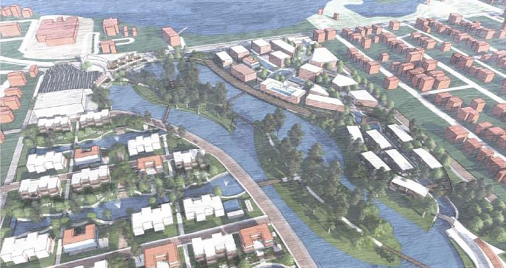
Hydro-Urbanism: A Walkable, Coastal Neighborhood Designed to Withstand Flooding and Use Water as A Design Asset by Zachary Faza, M.Arch ’23
Florida Agricultural And Mechancial University | Advisor: Kyle Spence
Located on the low-lying, sandy peninsula of Pinellas County, St. Petersburg, Florida, is a coastal city that has much at risk from hurricanes and heavy rainfall events. No Florida county has more buildings and more value at risk in Category 1 storms.
When a severe storm impacts a coastal city, high winds build up and push the water from the sea over the land. This is called storm surge, and it can cause devastating damage like that seen during 2022 Category 4 Hurricane Ian impacting this region of the State.
Zachary’s design-research investigative thesis presents research on existing case studies of aesthetically pleasing, multi-beneficial flood infrastructure that benefits society beyond flood control. This project applied intuitive thought to produce a design proposal for a walkable, 40-acre master-planned development that integrates flood-adaption infrastructure as aesthetic and recreational features.
The proposed master planned development orients around a central pond serving as a water retention feature and encloses two public park islands. This pond connects to a site-wide network of waterways and bioswales (naturally filtering landscape features) designed to absorb, filter, and store stormwater runoff from neighborhood roads.
Around the pond are several distinct built areas, each with latent design exploration. The primary regions built around the pond include a Canal-Front residential area that has elevated structures that looks inwards onto tree-lined canal parks, the Waterside Shops mixed-use shopping center with a grocery store, waterfront commercial spaces, and apartments, and the public Forest Park that spans two islands within the central pond and forms the spine of the development’s pedestrian and bicycle circulation network.
Zack’s project is a design exercise demonstrating that flood adaptation measures can be an aesthetically pleasing part of a holistic urban design solution that mitigates damage from floods and storms and creates vibrant, profitable commercial, public, and residential areas.
This project won the FAMU Three-Minute Thesis First-Place Award
Come back next week for Part II!